plugin

Download tiles for offline background maps in five steps

The latest version of Mergin Maps plugin(2023.4.0) now supports downloading vector tiles for offline use. This means that even if you are using an older version of QGIS, like the 3.28 LTR, you can still use vector tile layers in offline mode with Mergin Maps.

About vector tiles

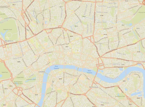
In many cases, vector maps are better for background data since they are smaller in size and can have more flexible styling. There are also many options for vector map sources in QGIS such as OpenStreetMap, CartoDB and ESRI Basemap. You can even download the Mergin Maps default basemap style.

Preparing vector tile layer for offline use

Downloading a vector tile layer for offline use in Mergin Maps is simple, just follow the five steps below:

1. Open your Mergin Maps project in QGIS

2. In the Layers panel, right click on the vector tile layer and choose ‘Make available offline…

3. In the Download Vector Tiles dialog, set the Extent, Maximum zoom level, Tile limit and Output path for the MBTiles file to the desired settings. If you will be synchronising the tiles for offline use, make sure they are in the Mergin Maps project folder with the rest of your project. 
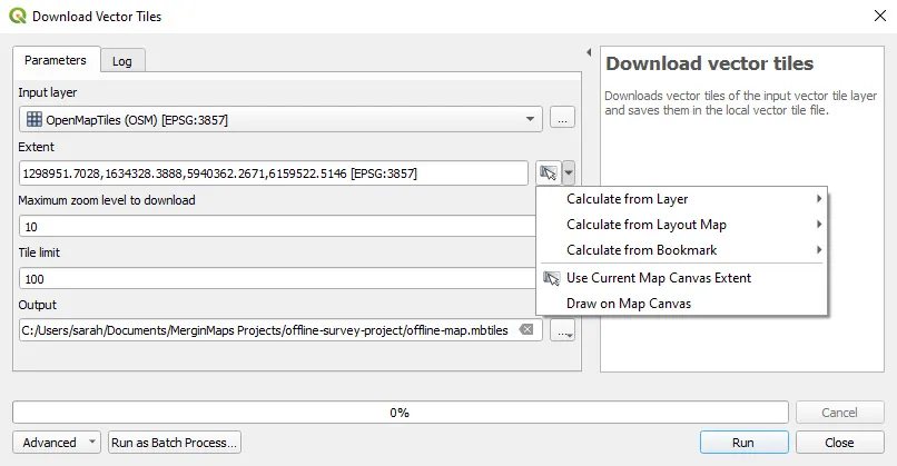
4. Click Run

5. Save and synchronise your project.

That’s it! Now your colleagues in the field can download the vector tile layer the next time they synchronise in the app and use the layer in offline mode. 

It is important to note that raster and vector tiles can use a significant amount of storage, especially if they are for high-resolution data. This may increase loading times for users in the field so may only be practical to use when you know users will be working with limited connectivity and in such cases might be best to make sure they synchronise their devices while they have a fast mobile connection or wifi access. 

You can find more detailed instructions about using vector tiles for offline mode in our documentation.

Now let’s go capture some field data... offline!

You might also like

Mergin Maps

Mergin Maps app is getting a fresh new look

March 28, 2024

Mergin Maps

QField vs. Mergin Maps - App Comparison

March 1, 2024

Mergin Maps

Hello from Mergin Maps!

February 13, 2024

plugin

Support tip: Downloading a previous version of your project

January 31, 2024

Mergin Maps

Mergin Maps 2023: our year in review

December 28, 2023

mobile

Mergin Maps is now faster and more stable than ever

November 15, 2023

partners

We've partnered with MarXact for high-precision surveying in Mergin Maps

October 27, 2023

event

Come see us at INTERGEO 2023 in Berlin

September 29, 2023

Mergin Maps

Mergin Maps Gets a Brand Refresh

September 27, 2023

Mergin Maps

We’ve added the ability to customise photo names in Mergin Maps!

August 31, 2023

mobile

You asked for it and we delivered… Position tracking in Mergin Maps!

August 22, 2023

Mergin Maps

Features wishlist - Help us help you!

July 27, 2023

Mergin Maps

Check out the Mergin Maps interview on App of the Day

May 4, 2023

event

Mergin Maps hope to see you at GeoBusiness London 2023

May 2, 2023

Mergin Maps

Worried about using open-source geospatial software for your business? Mergin Maps support is here for you!

April 28, 2023

Mergin Maps

Camptocamp partners with Mergin Maps to deliver open source GIS solutions

April 25, 2023

Mergin Maps

Subscription tiers are going to change

April 18, 2023

Mergin Maps

Mergin Maps Community and Enterprise Editions

March 31, 2023

Mergin Maps

Introducing Workspaces: Simplified Collaboration

January 31, 2023

Mergin Maps

Mergin Maps: a year in review (2022)

December 20, 2022

Mergin Maps

Mergin Maps in MapScaping podcast

December 15, 2022

plugin

View and track changes in QGIS

December 14, 2022

By clicking “Accept All Cookies”, you agree to the storing of cookies on your device to enhance site navigation, analyze site usage, and assist in our marketing efforts. View our Cookie Policy for more information. Deny cookies here.