
Two great choices for connecting your QGIS project to a mobile device for field data collection
One of the major benefits of using open-source software is that there is the availability to choose from multiple platforms and develop a workflow that best fits your needs instead of being locked in to a single solution. For QGIS users who want to collect data in the field, the two most popular choices are Mergin Maps and QField.
If you’re thinking about choosing a mobile app to connect your QGIS projects to the field for mobile connectivity, we want to help you choose the best solution for your needs. Mergin Maps and QField have a lot in common, so let’s talk about how they are similar before we explore some of the differences.
Both are built around QGIS
Mergin Maps and QField are built around the QGIS ecosystem. Both apps use a QGIS plugin to prepare projects for mobile synchronisation. This allows you to design your data structure, relationships and symbology in QGIS and the apps will package your project and make it available for use on the mobile app in the field.
With both apps, a user can prepare a project in QGIS and follow the instructions for either app to prepare the app for use in the field. The style and appearance of the project symbology will be directly ported to the app in the field, meaning that you can control how your project will look while setting it up in QGIS and it will appear the same to mobile users.
The framework for project setup is so similar that it is easy to migrate a project from QField to Mergin Maps with just a few steps or vice versa.
Both apps are open-source
Mergin Maps and QField are both open source projects. This means that the code for either app is publicly available and published under an open source licence. They both also offer free-to-use versions of the apps. With QField, you can set up a project and use it with offline USB synchronisation between QGIS and your mobile device or have a free QFieldCloud subscription with a 100Mb limit. Mergin Maps has a Community Edition that you can download and set up on your own cloud infrastructure to deploy your own projects. Each of these community options come with their own documentation and vibrant user communities for support.
Comparison of the mobile apps
QField is a powerful field data collection tool for QGIS
The implementation of the mobile experience is where Mergin Maps and QField really start to differ. The QField mobile app is built to give the user more of a mobile QGIS experience. This means that the interface is more similar to that of QGIS. The user has an on-screen display of project layers and features that they can browse and view on the map in the field. In order to implement this, QField uses a concept of ‘Modes’. The default mode in QField is ‘Browsing’, this allows the user to view data on the map and carry out some functions like measuring the distance or area of a certain feature on the map or navigating from their current location to a feature on the map.
A user cannot edit any information in the project while in ‘Browsing’ mode, in order to add or edit features, they will need to open a menu and switch to ‘Edit’ mode. Once ‘Edit’ mode is enabled, a new set of buttons will appear on the interface allowing users to add or edit features using functions such as merge, split or edit/draw points, vertices or rings.
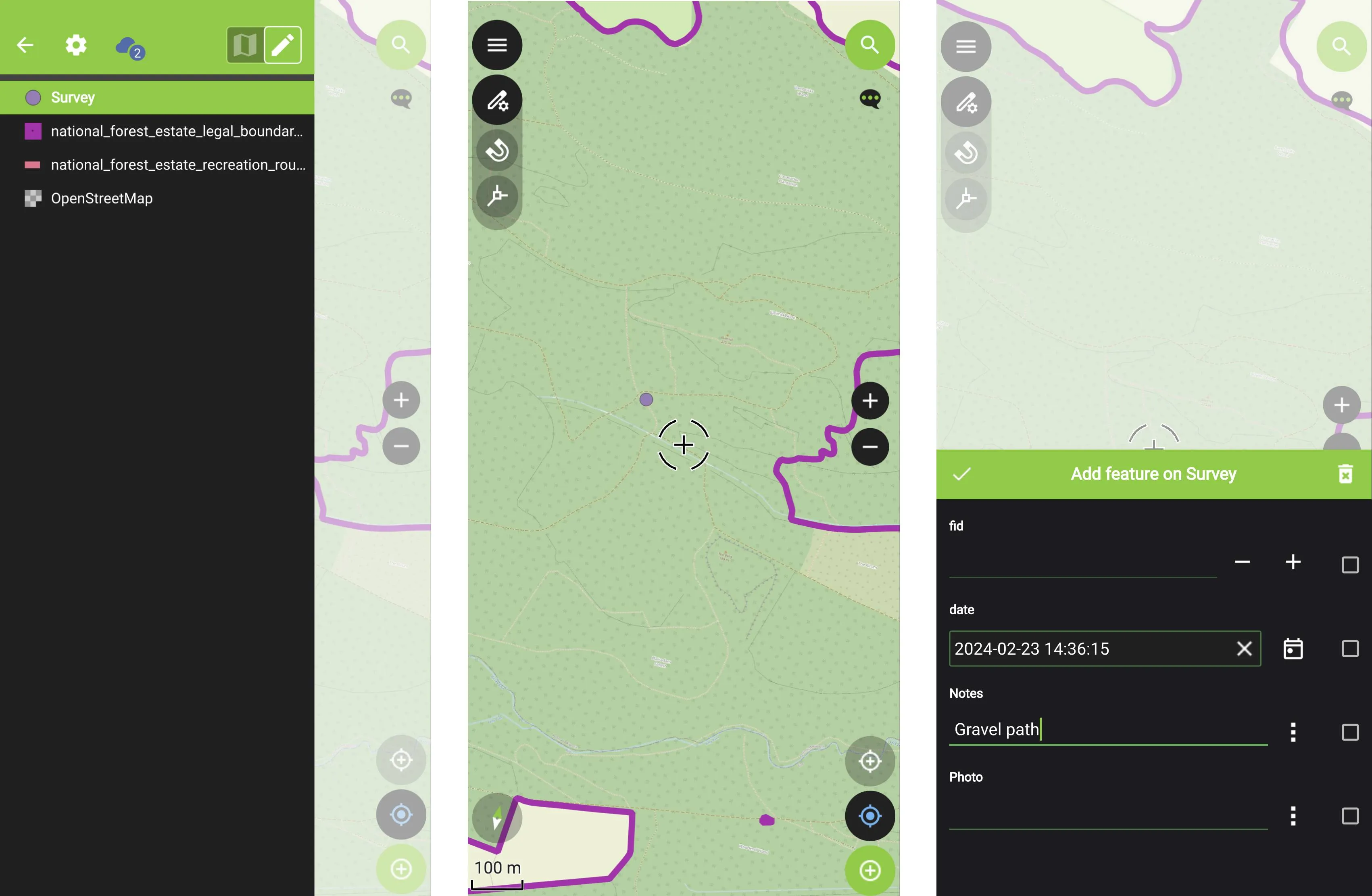
Once a feature has been created or selected, the user can also edit the attribute form for the feature.
Digitisation in QField can give users a lot of flexibility to edit and collect information in the field. However, there are quite a few buttons that may have unfamiliar symbology for new users and buttons are not labelled so it can take quite a bit of training for field workers who are less familiar with GIS software to get used to all of the options and features available.
Mergin Maps has an intuitive interface for ease of editing in the field
The streamlined interface of Mergin Maps and use of clear labels for buttons means that even users who have minimal GIS or technical experience can download a project and start collecting and editing data with minimal training.
One of the key differences from QField is that Mergin Maps does not have ‘modes’ in the app interface. A mobile user is able to browse or edit features in the app by default (assuming they have write permissions for the project). Rather than having a list of map layers and features on the main view of the project, a user simply needs to tap a feature on the map and a summary of the feature will appear. If they wish to edit the feature, they just click the edit button and they will have the option to either edit the attribute form or the geometry of the feature.
If the user wants to add a new feature, they touch the ‘Record’ button and then the ‘+’ to add a new feature. The type of feature will be determined by the layer so users can add points, lines or polygons depending on the layer type. Once a new feature is created, the attribute form will appear so they can enter the data.
.webp)
It is still possible to view a list of layers and features in each layer. However, rather than have this in the main view of the app, the user needs to select the ‘More’ menu button and choose ‘Layers’ from the menu. The user can also search for layers and features using the search box at the top of the Layer view.
It is also very easy to white-label Mergin Maps mobile. There are already several apps based on Mergin Maps on Google Play Store and App Store.
Cloud sync with Mergin Maps and QField
Synchronising a project from the field is the most important function of a field collection app. Both apps offer SaaS cloud services for users who wish to synchronise their data. QField offers QFieldCloud which has a free subscription for 100Mb and paid subscriptions for larger project storage and other features. Mergin Maps offers cloud services with a 28-day free trial and free subscriptions for education and small nonprofit users.
Mergin Maps and QFieldCloud have different concepts behind how they synchronise projects in the cloud.
QField users need to choose between online and offline editing. Online editing requires the project to be set up with a PostGIS database connection and users must have constant access to a reliable data connection. With offline editing, a GeoPackage or PostGIS database can be used and users download a copy of the project and edits are then consolidated after all data has been collected. If using a GeoPackage, the project can only be edited by users in the field and not by a desktop user on QGIS because the desktop file will be replaced when changes are synced. When creating a project in QField, the user needs to select how each layer of the project will be synchronised from five variable actions.
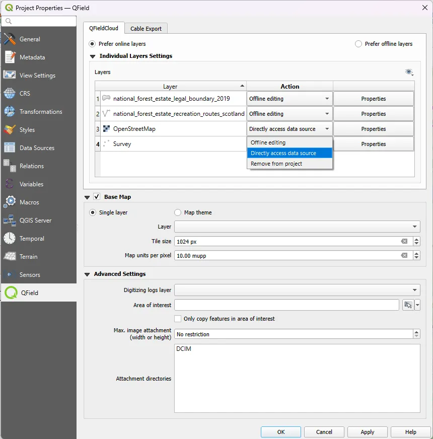
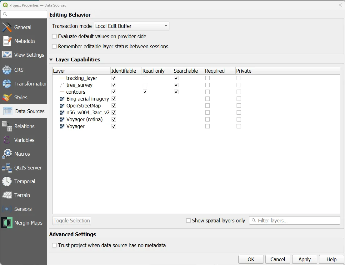
Mergin Maps uses Geodiff to create difference files from GeoPackages that are sent over the network and applied. Users can also edit the project on the desktop and in the field simultaneously and there are conflict management options if different users edit the same feature in-between synchronisations. No extra PostGIS data connection is required for simultaneous editing and project managers can set access for individual layers in the QGIS Project Settings dialogue (see screenshot below). This makes synchronisation with Mergin Maps inherent for mobile users to upload and download changes simultaneously with a single push of the button. With QField, there are multiple steps that need to be taken depending on the synchronisation mode selected.
Self-hosting options
With Mergin Maps, you can use the standard SaaS service or alternatively, you can host the service on your own infrastructure. To host your own service, you can set up Mergin Maps Community Edition (free and open source) or Mergin Maps Enterprise Edition, which comes with workspaces and regular security updates with a flexible pricing structure depending on the size and needs of your organisation. QFieldCloud also has an open-source repository for self-hosting available on their GitHub page. Users who are interested in a support package for their implementation can reach out to OPENGIS with their enquiries.
Price comparison for cloud services
One consideration for users deciding to use Mergin Maps or QFieldCloud is the cost of the cloud services offered for each application. For individual users or small organisations, the price of each service is comparable. However, these costs start to differ considerably for larger organisations or those who need extra storage for larger projects.
QFieldCloud manages subscriptions at an individual user level. This means that larger organisations need to add a new subscription for each user, partner or volunteer that they wish to have on their project. The individual subscription tiers for QFieldCloud are as follows:
Alternatively, Mergin Maps has a flat fee structure that allows a user to select a subscription tier based on several features such as number of users, number of projects, project history and storage size. Additionally, subscriptions are not set for individual users. Instead, Mergin Maps uses a concept of ‘Workspaces’ to manage subscriptions. This means that a workspace could include only one user or an entire organisation. This makes it easy to scale your subscription if your organisation needs change. It is also a benefit that an organisation can transfer ownership of an account at the organisation level instead of having access tied to an individual user. The Mergin Maps subscription tiers are as follows:
For an individual user, the price between Mergin Maps and QFieldCloud is close by comparison, so it really comes down to which features are best for your needs. However, for teams and larger organisations, Mergin Maps can be significantly cheaper due to larger storage limits and the organisation of subscriptions by workspaces. Let's look at some comparisons:
A small team of four users who need at least 4Gb of storage for projects and photo attachments:
QFieldCloud:
- 4 x €20 Organization subscriptions
- 3 x €5 for additional storage
- Total: €95/month (€84/month for first six months)
Mergin Maps:
- One €78.00/month (€63.2/month with annual billing) Premium subscription
A larger organisation with 15 users and at least 15Gb of storage for projects and photo attachments:
QFieldCloud:
- 15 x €20 Organization subscriptions
- 14 x €5 for additional storage
- Total: €370/month (€310/month for first six months)
Mergin Maps:
- One €292.5/month (€237/month with annual billing) Premium subscription
For an annual subscription in the first year, the small team would save up to €315.6 with Mergin Maps and the larger organisation could save up to €1,236 if they use annual billing.
Customer support
Another issue to consider before choosing between Mergin Maps or QFieldCloud is the level of customer support available. QFieldCloud users can get support from community discussion pages on GitHub and StackExchange. For users who need a more dedicated support package, OPENGIS also offer paid training and service level agreement (SLA) packages.
All users of Mergin Maps can access community Slack and GitHub pages where they can report bugs, ask for advice and recommend new features. Additionally, users of Mergin Maps subscription packages get email support included with the service. Mergin Maps also has SLA packages for organisations and users who need more dedicated support options.
Conclusion
As you can see, both Mergin Maps and QField offer great opportunities to link mobile field data collection with QGIS. Each app has its strengths that cater to different types of users. QField is an excellent choice for power users who want to experience a more direct implementation of QGIS features in the field. On the other hand, Mergin Maps is designed for ease of use in the field so a surveyor with minimal GIS experience could download the app and start collecting data in minutes with minimal training or time spent reading documentation. Mergin Maps also has a lower cost for teams and larger organisations who need multiple users, more storage for larger projects, email support and less restrictive version control.
Don’t just take our word for it, let’s hear what some of our users have to say:
iOS
*****
Studkier 02/01/2024
Very satisfied!
Our volunteer organization has used Mergin Maps for two years. Our team of approximately 40 citizen scientists use the app to monitor about 200 nest boxes for a bird species whose numbers are in decline. We record a variety of variables regarding fledging success throughout the breeding season. This app has revolutionized our ability to monitor the birds in near-real time. Simply put, we could not keep up with the field data workload without this app! The wide variety of tools and options at our fingertips is more than we could’ve ever hoped for, and it’s integration with QGIS is seamless. I’ve used a number of field recording devices over the years, and Mergin Maps is equal to or better than any of them, and when the free price of QGIS is factored in, this app is a tremendous bargain.
*****
Jacqsmaps 04/12/2023
Perfect for research and fieldwork
I have been using Mergin Maps for the past three years, first for my Masters research and now for my PhD. This app allows me to visualize and navigate to field sites on my phone (offline!), collect data at each point, and have my projects sync seamlessly with the cloud for later download and use in QGIS.
I have multiple projects in Mergin Maps and have used about 1/10 of my free storage limit, so the free storage is plenty to get me through all of grad school and beyond. Would recommend without hesitation to anyone doing field research.
Android
*****
LWS 01/30/2024
Beautifully made, working everytime i use it. I have been using my own server, everything goes well. Keep it up.
*****
Thomas Lawrence 02/10/2023
I have nothing but good things to say about Mergin Maps. I am using it for a large number of projects and it is working extremely well. It is simple, easy and it really delivers. It has been an absolute lifesaver for collecting data out in the field especially with its offline capabilities. I have also had great experience with their support as they return emails very quickly providing detailed information on possible solutions to any small problems I have had.